| If yetis exist, they exist in Tajikistan. Ever since a meteor smashed
into the high Pamirs 10 million years ago and left a crater lake now
known as Karakul(east part of the country),Tajikistan has known better
than to separate the natural and the supernatural. Nine tenths of
this untamed frontiers land is mountain. Half of it, including nearly
10,000 square km, is over 3000 m. high, the domain of the yak, the
eagle, the snow leopard and, mountain dwellers solemnly attest, the
abominable snow man. Tajiks are of Indo-European rather than Altaic
stock, and their language is Persian, not Turkic.
Tajikistan is an ancient state situated in the south-east of Central
Asia. Uzbekistan and the Kyrgyz Republic lie to the west and north,
China and Afghanistan to the east and south.
 The
Republic of Tajikistan is not large, occupying an area of 143 thousand
square kilometers(350 km from north to south, and 700 km from west
to east).The more than 6 million population of Tajikistan is ethnically
diverse. While Tajiks comprise more than 70% of the population,
almost 70 other nationalities live in Tajikistan. These nationalities
include Uzbeks, Russians, Kyrghyz, Tatars, and Ukrainians among
others. The state language of the country is Tajik and Russian also
used for documentary as well. More than 90% of the population is
Muslim. The people are known for their industrious nature, settled
way of life, devotion to family, children, native land and home.
They are very hospitable, kind-hearted, friendly and respect their
customs and traditions. Life in an area situated at the main crossroads
of eastern civilization has given them continuous access to the
achievements of other cultures. The first settlement on the territory
of today's Tajikistan date back to the end of upper Paleolithic
period(15-20 thousand years ago)Archeological finds, the works of
Herodotus and other written evidence provide information on trading
relations, customs, and the rituals of the nation. For many centuries
the country, involved mainly in trading with neighbors suffered
from foreign invasions by the troops of Alexander the Great, steppe
nomads, Arabs and Tartar-Mongols. The
Republic of Tajikistan is not large, occupying an area of 143 thousand
square kilometers(350 km from north to south, and 700 km from west
to east).The more than 6 million population of Tajikistan is ethnically
diverse. While Tajiks comprise more than 70% of the population,
almost 70 other nationalities live in Tajikistan. These nationalities
include Uzbeks, Russians, Kyrghyz, Tatars, and Ukrainians among
others. The state language of the country is Tajik and Russian also
used for documentary as well. More than 90% of the population is
Muslim. The people are known for their industrious nature, settled
way of life, devotion to family, children, native land and home.
They are very hospitable, kind-hearted, friendly and respect their
customs and traditions. Life in an area situated at the main crossroads
of eastern civilization has given them continuous access to the
achievements of other cultures. The first settlement on the territory
of today's Tajikistan date back to the end of upper Paleolithic
period(15-20 thousand years ago)Archeological finds, the works of
Herodotus and other written evidence provide information on trading
relations, customs, and the rituals of the nation. For many centuries
the country, involved mainly in trading with neighbors suffered
from foreign invasions by the troops of Alexander the Great, steppe
nomads, Arabs and Tartar-Mongols.
The first Tajik sate emerged in 892,getting independent from Arab
Khalif. The development which began in the Samanid Epoch, was characterized
by the restoration and fortification of
warraveged cities and greater attention to the culture, art and
architecture. Samanid state brought to the world the most famous
scientists and philosophers - Abu Ali Ibn Sina(Avicenna), Tajiks
also venerate Firdousi, a poet and composer of the Shah-nameh (Book
of Kings),the persian national epic, and Omar Khaiyam.
Tajikistan is remarkable for it's variety and contrasting nature
conditions. It is determined by it's being far from oceans in the
zone of Eurasia and mountainous relief. In summer the temperature
is 30-40 degrees above zero in the plains and in winter time is
8-10 degrees below zero but in mountain area is cold.93% of the
territory of Tajikistan is covered by mountains, among them the
highest - the Pamirs where there are the biggest mountain chains
of Asia - Karakorum, Kuenlun and Hindikush. The Pamirs is called
the "Roof of the World", because some of it's peaks rise
to a height of 7495 ms above sea level. It is the peak of Ismoil
Somoni. There is also the highest mountain salty lake Karakul and
the biggest ice-glacier Fedchenko (65 km).
The climate of Tajikistan is very different. It is subtropical
in low valleys, it is temperate in middle circles of mountains and
cold in high mountains. For that reason, it is possible to grow
most sun loving cultures(including citric plants)and get 2-3 harvests
per year. In high mountains of Tajikistan there are great supplies
of ice and snow.Tajikistan is also rich of lakes. Among them the
famous - Iskanderkul named after Alexander the Great, lake - "Seven
bellies" of Fann mountains.
Rugged and mountainous, Tajikistan sits at the heart of Central
Asia with China to the east and the Indian sub-continent to the
south. Three major Silk Road routes ran through it's present day
territory. These three routes were the Sogdian, or the North Road,
which connected Samarkand and Kashgar(China);the Karategin Road
between Termez(Uzbekistan), and Kashgar; and the Pamir Road linking
Balkh (Afghanistan) and Tashkurgan (China).
DUSHANBE - THE CAPITAL OF TAJIKISTAN
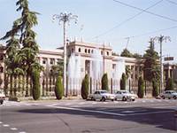 DUSHANBE
- is the capital of the republic of Tajikistan with the population
of more than 600 thousand peoples and majoring more than twenty
embassies of foreign countries. DUSHANBE
- is the capital of the republic of Tajikistan with the population
of more than 600 thousand peoples and majoring more than twenty
embassies of foreign countries.
At the beginning of XX cc., Dushanbe was a small village 500 clay
houses. Situated in the centre of the Hissar valley, at the cross
road of caravan paths, it was famous for it's picturesque Monday
bazaars(Dushanbe means Monday in Tajiks).The capital is situated
at the confluence of two rivers, the Varzob and the Kofarnihon.
The city is multinational and present time is considered to be the
scientific, cultural and industrial developed centre of the country.
There are museums ,theatres, universities, hotels and around the
city there were preserved some ancient historical monuments like
Hissar fortress and etc.....
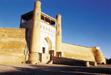
The Hissar Historic and Cultural Reserve located near the capital
Dushanbe is a fascinating archaeological complex which scholars
say dates from the 25th century. Several mosques, a caravansaray,
medresse and a mausoleum have all been excavated and are on display.
 In
ancient times such towns as Bukhara, Samarkand, Penjikent were the
centers of the development of Zoroastrian culture. After the invasion
of Arabians Zoroaster’s collapsed into pieces to Zerafshan and Pamir.
Ancient towns of Great Silk Road as Khujand, Penjikent, Istaravshan,
Samarkand, Bukhara, Khiva, Merv, Osh were the places of vital, economic In
ancient times such towns as Bukhara, Samarkand, Penjikent were the
centers of the development of Zoroastrian culture. After the invasion
of Arabians Zoroaster’s collapsed into pieces to Zerafshan and Pamir.
Ancient towns of Great Silk Road as Khujand, Penjikent, Istaravshan,
Samarkand, Bukhara, Khiva, Merv, Osh were the places of vital, economic
interests of many countries of the world. This part of the world
was the crossroads of caravan roads connecting North-South, East-West,
and they led to China, India, Rome and to Europe. So, there are
22 cities and towns in Tajikistan. Cities such as Khujand (Alexandria
Eskhata),Uroteppa (Ustrushana) and Penjikent are among the most
ancient settlements in the east.
ABOUT KHUJAND
 Central
Asia was also the field of battles, where Alexander the Great with
his troops entered through the west and invaded almost the whole
Central Asia. The last bulwark of Alexander the Great was Khujand.
The age of the ancient town Khujand is 2500 years and in the times
of Greek’s invasion it was called "Alexandria Eskhata". Central
Asia was also the field of battles, where Alexander the Great with
his troops entered through the west and invaded almost the whole
Central Asia. The last bulwark of Alexander the Great was Khujand.
The age of the ancient town Khujand is 2500 years and in the times
of Greek’s invasion it was called "Alexandria Eskhata".
From the east there was the invasion of Chingizkhan. The troops
of Tatar-Mongol hordes for a long time stayed at the gates of Khujand,
and the ruler of the town XII cc., Temurmalik kept the fortress
of the town for a long. One can see the ruins of that fortress in
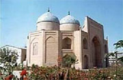
our times as the symbol of heroism. At it's height, the city was
a renewed religious centre and today the magnificent citadel, mausoleum
of Sheikh Muslihiddin and an XVIII-cc., mosque are among the monuments
which attract visitors.
Geographically Khujand is situated along the picturesque river of
Sirdarya, on both it's banks and is called "The Gates of Fergana
Valley".
Today Khujand is the developed scientific, cultural and economic
centre of Northern Tajikistan. There preserved also some ancient
monuments of history, religion and the culture.
Welcome to ancient Penjikent
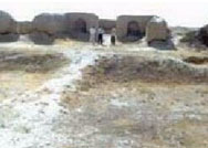 it is
Sogdian city which flourished from the V-cc to VIII-cc. A.D. It
is so well preserved it has been dubbed "Central Asia's Pompei".
An opulent governor's palace, houses, and temples can be seen.At
one time Sogddiana controlled a key section of the Silk Road,but
in the VIII-cc., empire collapsed and the people fled to the mountains.Descendants
of this ancient kingdom still live in the more remote regions of
present day Tajikistan named Yagnob Valley and still spoke a remote
dialect of Sogdian.The ancient Sarazm,some 20 kms from Penjikent,is
one of the most ancient settlements of Central Asia,dating from
Neolyth period. it is
Sogdian city which flourished from the V-cc to VIII-cc. A.D. It
is so well preserved it has been dubbed "Central Asia's Pompei".
An opulent governor's palace, houses, and temples can be seen.At
one time Sogddiana controlled a key section of the Silk Road,but
in the VIII-cc., empire collapsed and the people fled to the mountains.Descendants
of this ancient kingdom still live in the more remote regions of
present day Tajikistan named Yagnob Valley and still spoke a remote
dialect of Sogdian.The ancient Sarazm,some 20 kms from Penjikent,is
one of the most ancient settlements of Central Asia,dating from
Neolyth period.
Welcome to ancient Istaravshan (former Uro-Teppa)
Istaravshan (former Uro-Teppa) is one of the most ancient and beautiful
cities in Tajikistan and it's long history includes capture by Alexander
the Great. Besides a number of mosques, museums and me dresses,
he surrounding region also contains rich archeological treasures,
including the city Shakhristan.
Besides it's Silk Road sites, this robust and remote country boasts
the Pamir Mountain range, sometimes called "The Roof of the
World". From here spread the three great ranges of Central
Asia - the Hindikush, the Karakorum’s, and the Tien-Shan.
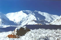
THE HIGHEST PEAKS OF TAJIKISTAN
The high peak I.SOMONI (Formerly Communism) peak(7495) - huge
ice massive with gigantic rocky tower above is the highest summit
in the Pamir. It is situated at the cross point of Academia Nauk
and the Pyotr Perviy ridges - so far remote district that explorers
could find access after 20 years research only. The first mountaineers
conquered in 1993 the peak" 7495"(that "peak Stalin"
- "peak Communizm").Now there are abundance of different
complexity grade routes on the top. Most popular and safe way -
over Dushanbe Peak(6950ms)from big Pamir Plateau.
EUGENIA KORZHENEVSKI PEAK(7105) - is situated a little to the
north of Samanids peak(13kms),also in the Academia Nauk ridge system.
The first mountaineers conquered this peak only in 1953. Now there
are about 10 different complexity grade routes on the top.
 LENIN
Peak(7134) - gigantic snow-covered mountain massive is situated
in the northern part of Pamir in Zaalaisky range and it is considered
to be one of the most easiest seven-thousanders which you can ascend
without special training and high - altitude climbing experience. LENIN
Peak(7134) - gigantic snow-covered mountain massive is situated
in the northern part of Pamir in Zaalaisky range and it is considered
to be one of the most easiest seven-thousanders which you can ascend
without special training and high - altitude climbing experience.
After the first ascent in 1928 climbers have used the abundance
of different complexity grade routes. Everyone can choose a suitable
route for his technical and physical abilities. Even not very skilled
climbers have the chance to conquer this peak .Lenin peak slopes
are the ideal site for the ski descend (from the top to the Lenin
glacier, altitude difference about 2,5 km) and paragliding.
The high peaks in Central Asia countries
KHAN-TENGRI Peak(6995) - that looks like gigantic ice pyramid is
located in the eastern part in Kyrghyzstan, and also Eastern part
of the Tengri-tag range in Central Pamir. After the first ascent
in 1931 climbers have used more than 10 difficult routes from all
four sides. But not all new routes have been discovered.
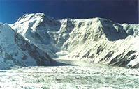 POBEDA(VICTORY)
PEAK(7439) - the highest summit of the snow-covered wall, stretching
for nearly 30 kms. Between Khan-Tengri and Pobeda summits(20kms)
there is one of the longest glacier in the world. Yuzhny Inilchek
(it's length exceeds 60 kms). Pobeda Peak is the most northern seventhousander
on earth. This mountain is covered with amounts of ice and it's
slopes are covered with snow. Strong winds challenge mountaineers
and raise snowstorm even in good weather. Experienced climbers affirm
that the ascent of Pobeda Peak can be compared with the conquest
of Himalaya'' peaks. The first mountaineers conquerred in 1938 the
formerly unknown peak. In 1944 the peak got it's name – Pobeda (Victory). POBEDA(VICTORY)
PEAK(7439) - the highest summit of the snow-covered wall, stretching
for nearly 30 kms. Between Khan-Tengri and Pobeda summits(20kms)
there is one of the longest glacier in the world. Yuzhny Inilchek
(it's length exceeds 60 kms). Pobeda Peak is the most northern seventhousander
on earth. This mountain is covered with amounts of ice and it's
slopes are covered with snow. Strong winds challenge mountaineers
and raise snowstorm even in good weather. Experienced climbers affirm
that the ascent of Pobeda Peak can be compared with the conquest
of Himalaya'' peaks. The first mountaineers conquerred in 1938 the
formerly unknown peak. In 1944 the peak got it's name – Pobeda (Victory).
There are some difficult routes on the top - on the centre of the
northern slope, on the eastern crest from Chon-Teren pass and along
the most safe way - over west Pobeda (Vazha Pshavela) from the Diky
pass(start from Zvyozdichka glacier icefall 4500m,altitude difference
about 3 km, icefall and steep snow in lower section (Diky Pass),very
steep ice and rocky ascent along northern ridge of West Pobeda (6918ms),
long traverse of the western crest(4kms) at an altitude 7000 ms.
PAMIR -ALAY MOUNTAINS
 PAMIR-ALAY
is buffer zone separating Tien Shan and Pamir and consists of two
main ridges Zaalaisky in the East and Zeravshansky in the West. PAMIR-ALAY
is buffer zone separating Tien Shan and Pamir and consists of two
main ridges Zaalaisky in the East and Zeravshansky in the West.
ZERAVSHANSKY RIDGE begins from the junction with two ridges Alaisky
and Turkestansky where mountain area Matcha is situated, towards
west - Fann mountains.
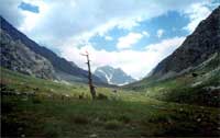
Mountainous MATCHA is a country of magnificent contrast, exotic
and legends .Relic Juniper forests and raising up to sky 4000-5000
ms peaks are neighbors to alpine meadows and grandiose ice falls,
turquoise lakes and rocky obstruction. The visitors of this "country"
will see Karakul-Katta lake - black "pearl" of Matcha
And unique Raygorodsky ice fall, appreciate the true value of valleys
and rivers of Kshemys, Nurlou, Kalay-Mahmud. There are good possibilities
of making trekking and ascents.
ABOUT FANN MOUNTAINS
 The FANN
MOUNTAINS is the name of a mountain massif which forms part of the
Pamir-Alay and is situated in the very heart of Central Asia, which
lie in 200 kms east of Samarkand. The FANN
MOUNTAINS is the name of a mountain massif which forms part of the
Pamir-Alay and is situated in the very heart of Central Asia, which
lie in 200 kms east of Samarkand.
The Fann mountains boast more than ten peaks with a height of over
5000 meters. Beautiful Mt. Chimtarga (5487ms) is the highest peak
in the area.
The banks of the numerous crystal-clear lakes are overgrown with
forests of relic archa-tree, which can be found only here. The trunks
of the ancient archa tree wound into a spiral by the severe winter
winds, reduce an unforgettable impression by their fancy forms.
Birch trees, poplars, mountain blue barberry, wild cherry trees
and many medicinal herbs grow in the valleys.
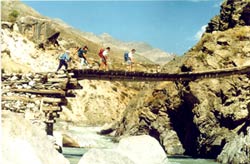
Due to it's fine climate, this area is very attractive for trekkers,
hikers, climbers, lovers of outings on horseback, etc. Rains, cloudy
skies, or strong winds are rather here. The time from June to September
is the most favorable for travels.
The tour company "Pamir travels" Co. ltd. invites it's
clients to get an idea of life, customs, traditions, and handicrafts
of the local people. This can be mostly done on the road to visit
the many mountain lakes.
Tajikistan Geography
Location: Central Asia, west of China
Geographic coordinates: 39 00 N, 71 00 E
Map references: Commonwealth of Independent States
Area:
total: 143,100 sq km
land: 142,700 sq km
water: 400 sq km
Area—comparative: slightly smaller than Wisconsin
Land boundaries:
total: 3,651 km
border countries: China 414km, Afghanistan 1,206 km, Kyrgyzstan
870 km, Uzbekistan 1,161 km
Climate: middle altitude continental, hot summers, mild winters;
semiarid to polar in Pamir Mountains
Terrain: Pamir and Alay mountains dominate landscape; western Ferghana
Valley in north, Kofarnihon and Vakhsh Valleys in southwest
Elevation extremes:
lowest point: Syrdariya 300 m
highest point: Kullai I.Somoni (former Communism) -7,495 m
Natural resources: significant hydropower potential, some petroleum,
mercury, brown coal, lead, zinc, antimony, tungsten
Land use: arable land: 6% ; permanent pastures: 25% ;forests and
woodland: 4% ;other: 65% (1993 est.)
Irrigated land: 6,390 sq km (1993 est.)
Environment—current issues: inadequate sanitation facilities; increasing
levels of soil salinity; industrial pollution; excessive pesticides;
part of the basin of the shrinking Aral Sea suffers from severe
over utilization of available water for irrigation and associated
pollution
Environment—international agreements:
party to: Biodiversity, Climate Change, Desertification, Ozone Layer
Protection
signed, but not ratified: none of the selected agreements
NATIONAL HOLIDAYS:
The official national holidays which celebrated in Tajikistan are
the following:
1st January The New year
8th March International Mother’s Day
21st March Navruz National holiday New Year
9th May Victory Day
22nd July Tajik language’s day
9th September The Independence Day
22-23rd September Idi Mehrgon-day of autumnal equinox
6th November Constitution Day
Also every year Tajiks celebrate the religious holidays such as
Idi Ramazon, Idi Kurbon.
The Tajik national food is very different and delicious. Some of
the most popular dishes which you may taste in every restaurant,
dinning-room and east Bazaar are shurpo, osh (palav), lagman, mantu,
kurutob, shakarob, sikh-kabob.
|